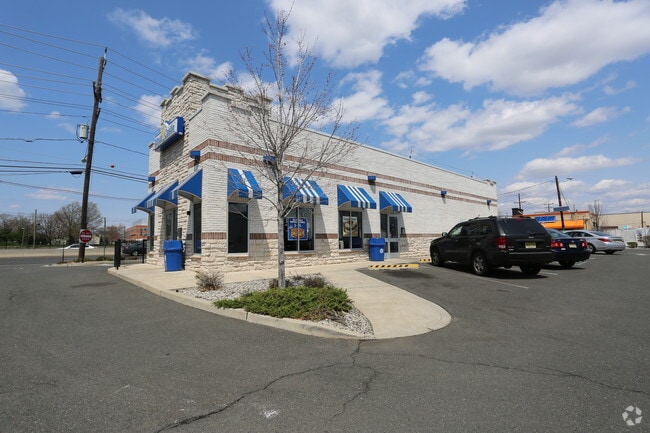
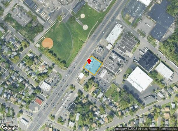
Property Record
1 State Hwy, Rahway, NJ 07065
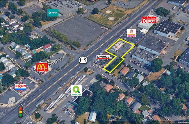
NEARBY LISTINGS FOR SALE OR LEASE
Property Detail
1 State Hwy
13-00389-0000-00023-01
Union
Commercialnec
New Jersey
X
23.1
34023C0057F
0.45 AC
2024
Parkway Cranford Corridor
2025
Northern New Jersey
035900
Newark, NJ-PA
1 SF
DEMOGRAPHICS near 1 State Hwy
1 Mile
3 Mile
5 Mile
2024 Total Population
13,713
136,871
406,874
2029 Population
13,814
135,090
400,079
Pop Growth 2024-2029
+ 0.74%
(1.30%)
(1.67%)
Average Age
40
40
40
2024 Total Households
5,554
49,262
143,944
HH Growth 2024-2029
+ 0.52%
(1.39%)
(1.71%)
Median Household Inc
$76,163
$85,434
$85,889
Avg Household Size
2.40
2.70
2.70
2024 Avg HH Vehicles
1.00
2.00
2.00
Median Home Value
$311,131
$366,778
$407,772
Median Year Built
1973
1959
1959
Nearby Places
Map Layers
Map Styles
 Street
 Aerial
- Restaurants
- Banks
- Shops
- Fitness
- Groceries
PUBLIC TRANSPORTATION
COMMUTER RAIL
Rahway (North Jersey Coast Line - NJ Transit Commuter Rail (NJ Transit), Northeast Corridor Line - NJ Transit Commuter Rail (NJ Transit))
DRIVE
WALK
Distance
Rahway (North Jersey Coast Line - NJ Transit Commuter Rail (NJ Transit), Northeast Corridor Line - NJ Transit Commuter Rail (NJ Transit))
4 min
1.3 mi
Linden (North Jersey Coast Line - NJ Transit Commuter Rail (NJ Transit), Northeast Corridor Line - NJ Transit Commuter Rail (NJ Transit))
DRIVE
WALK
Distance
Linden (North Jersey Coast Line - NJ Transit Commuter Rail (NJ Transit), Northeast Corridor Line - NJ Transit Commuter Rail (NJ Transit))
5 min
2.2 mi
AIRPORT
Newark Liberty International
DRIVE
WALK
Distance
Newark Liberty International
18 min
11.3 mi
LaGuardia
DRIVE
WALK
Distance
LaGuardia
50 min
31.7 mi
John F Kennedy International
DRIVE
WALK
Distance
John F Kennedy International
50 min
34.4 mi
Freight Ports
New York Container Terminal
DRIVE
WALK
Distance
New York Container Terminal
11 min
7.1 mi
SALE & LEASE HISTORY
LISTING DATE
SALE/LEASE

Sep 24, 2019
For Lease
Sep 03, 2022
For Lease
Sep 03, 2022
For Sale
Jan 15, 2020
For Lease
Nearby Properties
Address
Land Use
TOTAL SIZE
Lot Size
Zoning
Address
Land Use
TOTAL SIZE
Lot Size
Zoning
329,350 SF
15.99 AC
Address
Land Use
TOTAL SIZE
Lot Size
Zoning
10 SF
0.64 AC
Address
Land Use
TOTAL SIZE
Lot Size
Zoning
Address
Land Use
TOTAL SIZE
Lot Size
Zoning
404,985 SF
15.32 AC
R25
Address
Land Use
TOTAL SIZE
Lot Size
Zoning
37 AC
Address
Land Use
TOTAL SIZE
Lot Size
Zoning
1 SF
37 AC
Address
Land Use
TOTAL SIZE
Lot Size
Zoning
102.29 AC
Address
Land Use
TOTAL SIZE
Lot Size
Zoning
20.10 AC
Address
Land Use
TOTAL SIZE
Lot Size
Zoning
348,466 SF
15.98 AC
LI
Address
Land Use
TOTAL SIZE
Lot Size
Zoning
360,082 SF
22.45 AC
R50
Address
Land Use
TOTAL SIZE
Lot Size
Zoning
365,784 SF
12.73 AC
HIA
Address
Land Use
TOTAL SIZE
Lot Size
Zoning
78.47 AC
Address
Land Use
TOTAL SIZE
Lot Size
Zoning
298,080 SF
13.79 AC
LI
Address
Land Use
TOTAL SIZE
Lot Size
Zoning
10,240 SF
22.96 AC
LI
Address
Land Use
TOTAL SIZE
Lot Size
Zoning
232,134 SF
12.24 AC
LI
Address
Land Use
TOTAL SIZE
Lot Size
Zoning
90.28 AC
Address
Land Use
TOTAL SIZE
Lot Size
Zoning
8.43 AC
Address
Land Use
TOTAL SIZE
Lot Size
Zoning
7.24 AC
Address
Land Use
TOTAL SIZE
Lot Size
Zoning
29.03 AC
IL
Address
Land Use
TOTAL SIZE
Lot Size
Zoning
0.14 AC
C-4
Address
Land Use
TOTAL SIZE
Lot Size
Zoning
151.20 AC
O
Address
Land Use
TOTAL SIZE
Lot Size
Zoning
131,140 SF
10 AC
LI
Address
Land Use
TOTAL SIZE
Lot Size
Zoning
Address
Land Use
TOTAL SIZE
Lot Size
Zoning
400 SF
22.39 AC
R50
Address
Land Use
TOTAL SIZE
Lot Size
Zoning
262,455 SF
7.01 AC
R50
Address
Land Use
TOTAL SIZE
Lot Size
Zoning
34.49 AC
Address
Land Use
TOTAL SIZE
Lot Size
Zoning
231,654 SF
10.94 AC
LI
Address
Land Use
TOTAL SIZE
Lot Size
Zoning
19.90 AC
P
Address
Land Use
TOTAL SIZE
Lot Size
Zoning
46.30 AC
Address
Land Use
TOTAL SIZE
Lot Size
Zoning
182,250 SF
14.77 AC
LI
The World's #1 Commercial Real Estate Marketplace
Connect with us
© 2025 CoStar Group
The information above has been obtained from sources believed reliable. While we do not doubt its accuracy we have not verified it and make no guarantee, warranty or representation about it. It is your responsibility to independently confirm its accuracy and completeness. Any projections, opinions, assumptions, or estimates used are for example only and do not represent the current or future performance of the property. The value of this transaction to you depends on tax and other factors which should be evaluated by your tax, financial, and legal advisors. You and your advisors should conduct a careful, independent investigation of the property to determine to your satisfaction the suitability of the property for your needs.